
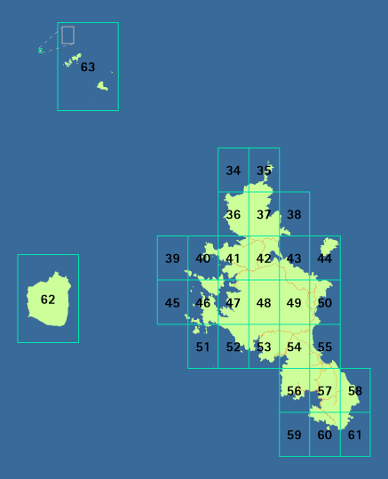
Use this map to ascertain which planning map your street is on:
Te Mahere ā-Rohe o Te Kaunihera o Tāmaki Makaurau – Te Tūtanga i Tīkapa Moana o Hauraki - Te tātai tiriti i Aotea Auckland Council District Plan - Hauraki Gulf Islands Section - Great Barrier Island street index
A
Aotea Road - map 41 (PDF 10.5MB)
Aotea Road - map 42 (PDF 11.0MB)
Aotea Road - map 43 (PDF 10.0MB)
Aotea Road - map 49 (PDF 10.9MB)
Aotea Road - map 50 (PDF 10.9MB)
B
Blackwell Drive - map 57 (PDF 10.8MB)
Blind Bay Road - map 53 (PDF 10.1MB)
Blind Bay Road - map 54 (PDF 10.7MB)
C
Camerton Road - map 54 (PDF 10.7MB)
Cape Barrier Road - map 57 (PDF 10.8MB)
Cape Barrier Road - map 60 (PDF 5.3MB)
Curreen Road - map 50 (PDF 10.9MB)
F
French Road - map 53 (PDF 10.1MB)
G
Garden Road - map 57 (PDF 10.8MB)
Glenfern Road - map 41 (PDF 10.5MB)
Gray Road - map 50 (PDF 10.9MB)
Gray Road - map 54 (PDF 10.7MB)
Gray Road - map 55 (PDF 8.2MB)
Greenside Road - map 55 (PDF 8.2MB)
H
Harataonga Road - map 49 (PDF 10.9MB)
Harataonga Road - map 50 (PDF 10.9MB)
Harataonga Walkway - map 43 (PDF 10.0MB)
Harataonga Walkway - map 44 (PDF 9.7MB)
Harataonga Walkway - map 50 (PDF 10.9MB)
Harpoon Hill - map 53 (PDF 10.1MB)
Hector Sanderson Road - map 54 (PDF 10.7MB)
Honey House Lane - map 55 (PDF 8.2MB)
I
Iona Road - map 54 (PDF 10.7MB)
K
Kaiaraara Bay Road - map 41 (PDF 10.5MB)
Kaiaraara Bay Road - map 47 (PDF MB)
Kaitoke Lane - map 54 (PDF 10.7MB)
Kaitoke Lane - map 55 (PDF 8.2MB)
Karaka Bay Road - map 41 (PDF 10.5MB)
Kawa Road - map 41 (PDF 10.5MB)
Kawa Road - map 42 (PDF 11.0MB)
Kowhai Valley Track - map 55 (PDF 8.2MB)
Kowhai Valley Track - map 57 (PDF 10.8MB)
L
Little Goat Road - map 57 (PDF 10.8MB)
M
Mabey Road - map 42 (PDF 11.0MB)
Macmillan Road - map 54 (PDF 10.7MB)
Mason Road - map 55 (PDF 8.2MB)
Maungatawhiri Road - map 56 (PDF 9.9MB)
Medland Road - map 55 (PDF 8.2MB)
Medland Road - map 57 (PDF 10.8MB)
Mitchener Road - map 57 (PDF 10.8MB)
Moana View Road - map 54 (PDF 10.7MB)
Motairehe Road - map 41 (PDF 10.5MB)
Motairehe Road - map 42 (PDF 11.0MB)
Mulberry Grove Road - map 57 (PDF 10.8MB)
O
O'Shea Road - map 50 (PDF 10.9MB)
Oceanview Road - map 54 (PDF 10.7MB)
Oceanview Road - map 55 (PDF 8.2MB)
Omanawa Lane - map 57 (PDF 10.8MB)
Omata Road - map 50 (PDF 10.9MB)
Oruawharo Lane - map 55 (PDF 8.2MB)
P
Pōhutakawa Place - map 57 (PDF 10.8MB)
Primrose Hill Road - map 55 (PDF 8.2MB)
Puriri Bay Road - map 56 (PDF 9.9MB)
Puriri Bay Road - map 57 (PDF 10.8MB)
R
Rosalie Bay Road - map 57 (PDF 10.8MB)
Rosalie Bay Road - map 58 (PDF 7.7MB)
S
Sandhills Road - map 55 (PDF 8.2MB)
Schooner Bay Road - map 56 (PDF 9.9MB)
Schooner Bay Road Extension - map 56 (PDF 9.9MB)
Shoal Bay Road - map 57 (PDF 10.8MB)
Sugar Loaf Road - map 55 (PDF 8.2MB)
T
Thomas Road - map 55 (PDF 8.2MB)
W
Walter Blackwell Road - map 54 (PDF 10.7MB)
Walter Blackwell Road - map 55 (PDF 8.2MB)
Whangaparapara Road - map 53 (PDF 10.1MB)
Whangaparapara Road - map 54 (PDF 10.7MB)
Find other Hauraki Gulf islands planning maps
-
Auckland Council District Plan - Hauraki Gulf Islands Section - inner island planning maps
See a map of the inner islands showing the locations of the Hauraki Gulf islands planning maps.
-
Auckland Council District Plan - Hauraki Gulf Islands Section - outer island planning maps
See a map of the outer islands showing the locations of the Hauraki Gulf islands planning maps.
-
Auckland Council District Plan - Hauraki Gulf Islands Section - Waiheke Island street index
Find your street on the Waiheke Island street index of the Hauraki Gulf islands planning maps.