About Ti Point to Sandspit SAP
The
Rodney Local Board endorsed this SAP in July 2025.
This SAP covers the area from the south of Mathesons Bay, including Ti Point and follows the coastline of Ōmaha Bay, Whangateau Harbour and Kawau Bay south to Sandspit and Brick Bay.
It includes, but is not limited to:
- Ti Point
- Whangateau
- Point Wells
- Ōmaha
- Takatu
- Tāwharanui
- Buckleton Beach
- Sandspit
- Matakana.
Map of areas covered by Ti Point to Sandspit SAP
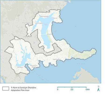
Map of the area covered by Ti Point to Sandspit Shoreline Adaptation Plan
Stages of Ti Point to Sandspit Shoreline Adaptation Plan
-
August 2025 - plan sent to the
Policy and Planning Committee for approval.
-
July 2025 - Rodney Local Board endorsed the plan.
-
December 2024 - July 2025 – feedback reviewed, final plan drafted and developed.
-
15 October - 6 December 2024 - further community engagement to ask for feedback on coastal adaptation strategies.
-
8 April - 31 May 2024 - initial community engagement took place to understand what community uses and values in relation to the coastline across the Ti Point to Sandspit SAP.
-
March 2024 – ongoing - local iwi engagement.
Read the full Ti Point to Sandspit Shoreline Adaptation Plan (SAP) report

